


Projects · 2026
Our referencesin the field
Interactive map of our projects: heritage, construction, agriculture, mining, energy. Filter by technology or industry to explore each mission in detail.
Interactive map · Referenced projects
Case studies · 2025 selection
Documented field missions, to the centimetre
Each reference below is a real field mission delivered to an identified client. Method, area, technology, deliverables: all traceable.
 HeritageAbomey, Bénin2025
100 ha LiDAR survey of the Royal Palaces of Abomey
Complete airborne LiDAR survey of a UNESCO World Heritage site for the ANPT. Orthophoto, DTM/DSM, point cloud and full geometric extractions: road footprints, buildings, roofs, perimeter walls and miscellaneous structures.
- Key figure
- 100 ha
- site UNESCO relevé en LiDAR
TechLiDAR aéroportéOrthophotographieMNT / MNSExtractions géométriquesClient : ANPT (Agence Nationale des Patrimoines Touristiques)
See case study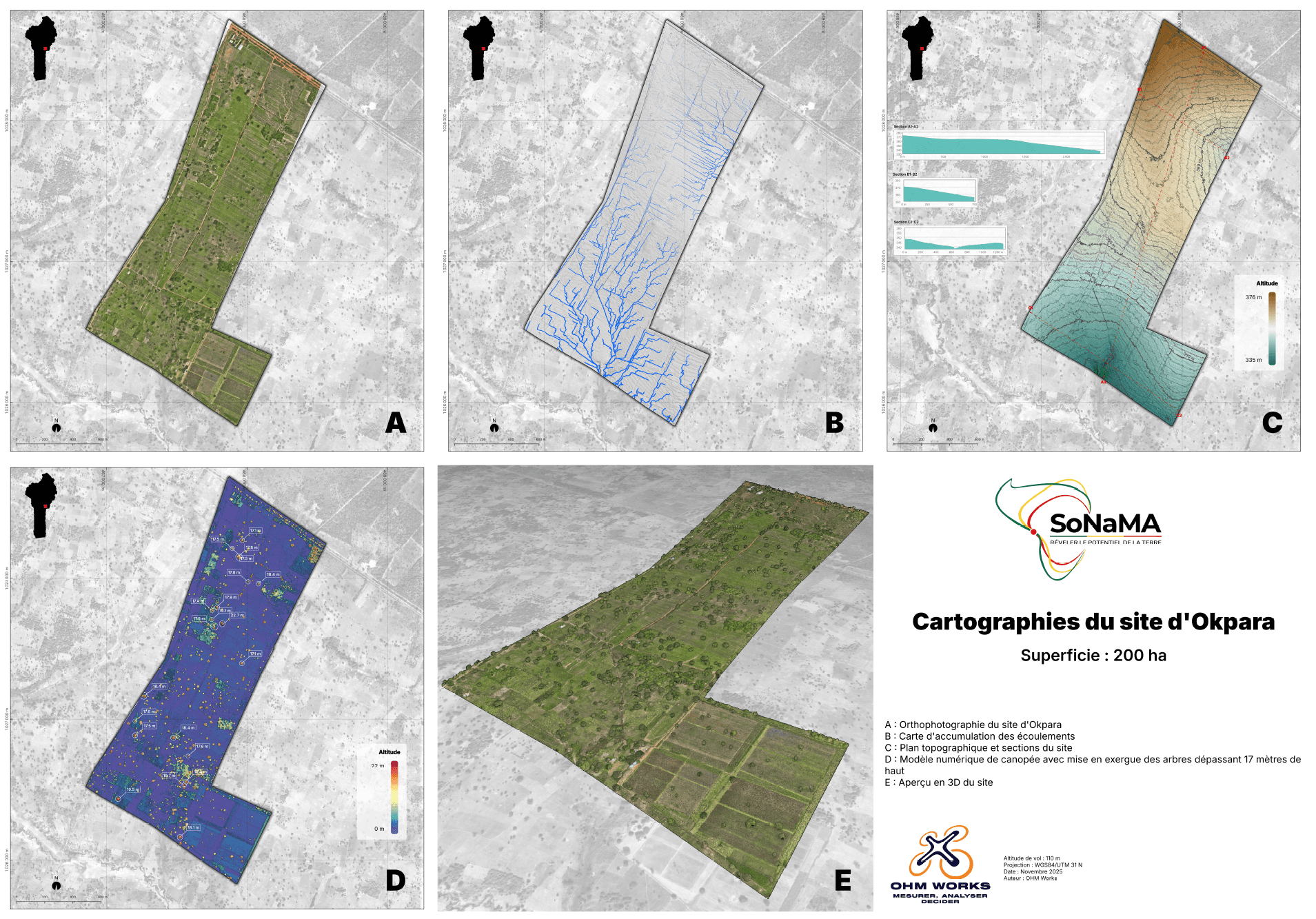 AgricultureParakou, Bénin2025
200 ha LiDAR survey of the Okpara Farm
LiDAR mapping of a large-scale integrated agricultural zone for SoNaMA. Orthophoto, DTM/DSM, point cloud and tree detection. Multi-layer restitution for agricultural planning and canopy monitoring.
- Key figure
- 200 ha
- zone agricole modélisée
TechLiDAR aéroportéOrthophotographieMNT / MNSDétection d'arbresClient : SoNaMA (Société Nationale de Mécanisation Agricole)
See case study Urban planningCotonou, Bénin2024-2025
Renovation of the GMK Stadium, Cotonou
Weekly drone site monitoring for Gregori International on the FIFA-grade renovation of Benin's national stadium. Photo/video reporting, documentation of critical phases and quality control through aerial imagery.
- Key figure
- FIFA
- mise aux normes du stade national
TechPhotogrammétrieReporting hebdomadaireModélisation 3DContrôle qualitéClient : Gregori International
See case study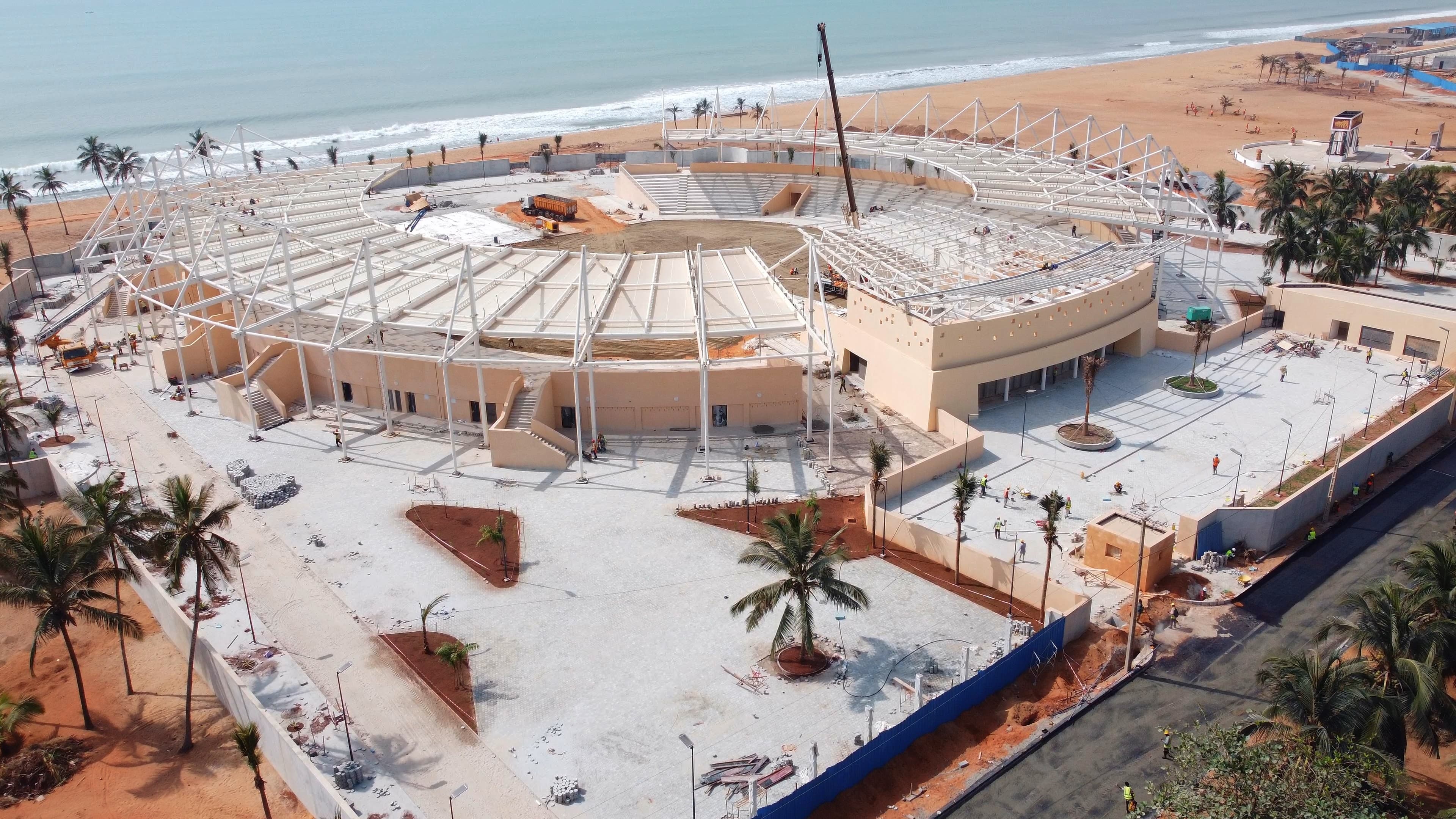 Urban planningOuidah, Bénin2024-2025
Construction of Hôtel La Marina, Ouidah
Drone site monitoring for Gregori International on the oceanfront hotel construction. Photo/video reporting, detailed site mapping, 3D progress modelling and tracking of landscaping works.
- Key figure
- 3D
- modélisation d'avancement multi-phases
TechPhotogrammétrieCartographie de siteModélisation 3DSuivi VRDClient : Gregori International
See case study Urban planningGanvié, Bénin2024-2025
Construction of the Ganvié Secondary School
Drone mission for Inspired Design on a lake-village construction site. Photo/video reporting, 3D modelling for architectural integration and quality control of pile foundations from hard-to-reach areas.
- Key figure
- Lacustre
- fondations sur pilotis suivies par drone
TechPhotogrammétrieModélisation 3DReporting photo/vidéoContrôle qualitéClient : Inspired Design
See case study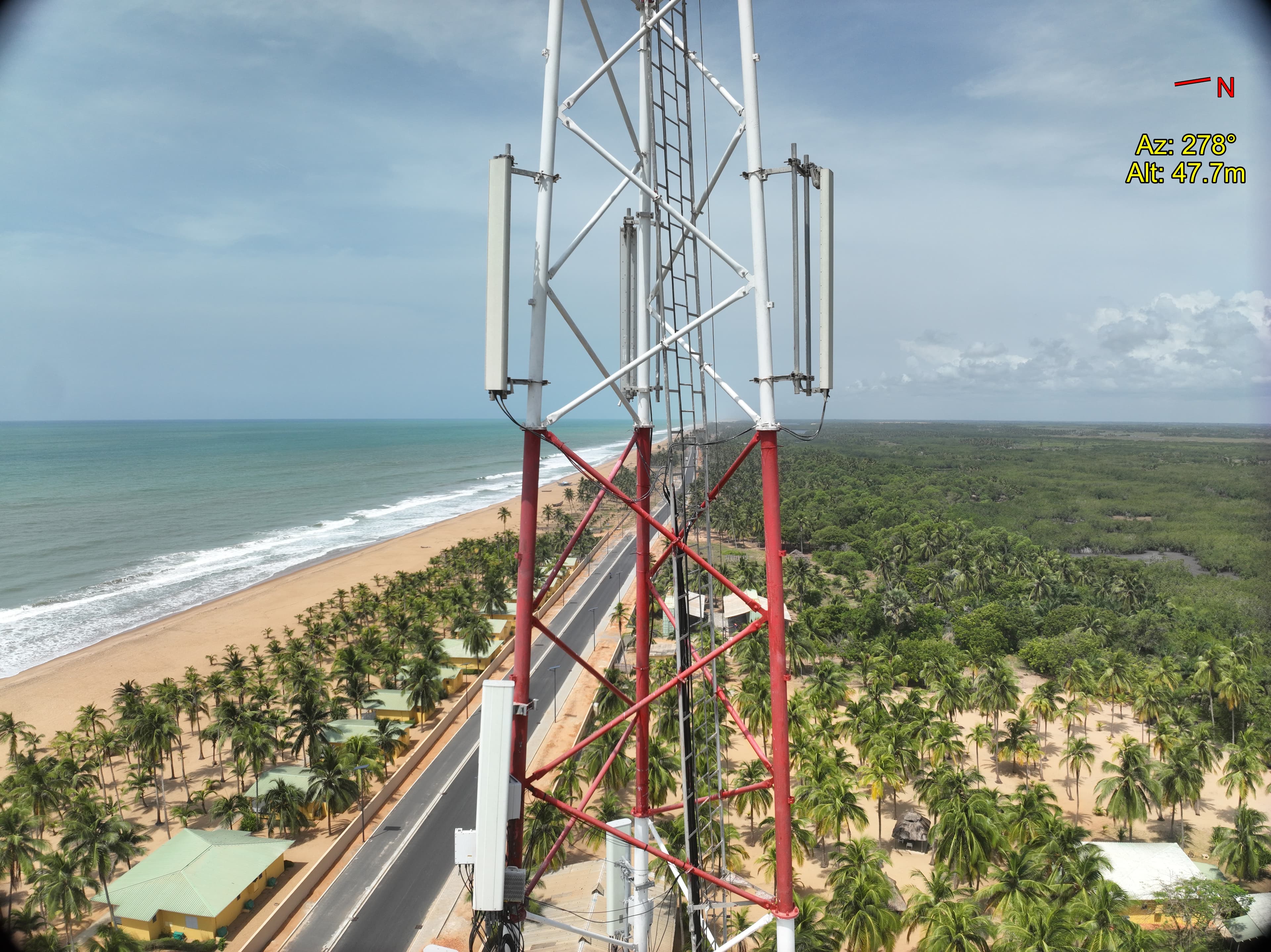 TelecomBénin2026
Digital twins of 4 MOOV BTS towers
Complete inventory of aerial and ground components for 4 MOOV Africa Bénin mobile sites. Full digital twin with azimuth, tilt, height and dimensions, complemented by a 360° virtual tour for remote operation without field travel.
- Key figure
- 4
- pylônes BTS jumellés numériquement
TechInventaire composantsJumeau numérique 3DTour virtuel 360°Azimut / Tilt / HauteurClient : MOOV Africa Bénin
See case study EnergyBénin2026
LiDAR and thermography of an HTB feeder for SBEE
Drone inspection of a high-voltage B line for SBEE: LiDAR survey of overhead lines, sag measurement, object detection in the clearance corridor, identification of dangerous trees, component inventory and thermographic hotspot detection.
- Key figure
- HTB
- lignes aériennes inspectées LiDAR + thermo
TechLiDAR aéroportéMesure de flècheDétection points chaudsInventaire composantsClient : SBEE (Société Béninoise d'Énergie Électrique)
See case study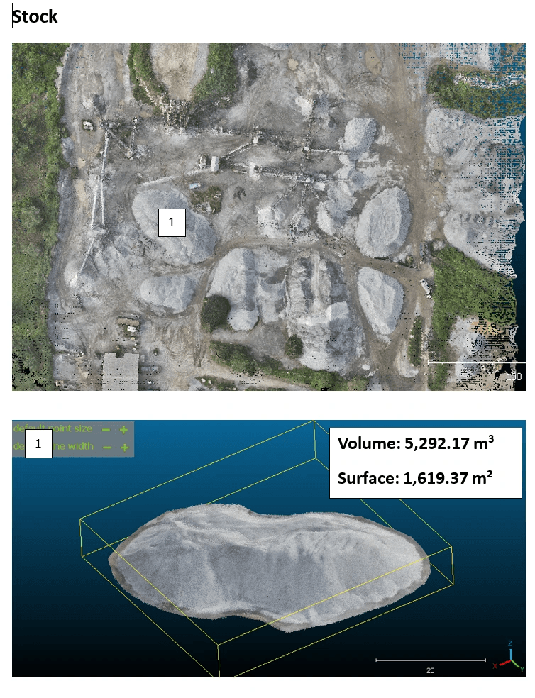 Mining & QuarriesBénin2025
Stockpile inventory of a BCG quarry
Drone mission for BCG (Bénin Carrière Granulat): orthophoto, DTM/DSM, high-resolution point cloud, stockpile inventory and geometric conformity check of operating slopes.
- Key figure
- ± 1 %
- tolérance volumétrique sur cubatures
TechPhotogrammétrieNuage de points HDCubatures stockpilesConformité pentesClient : BCG (Bénin Carrière Granulat)
See case study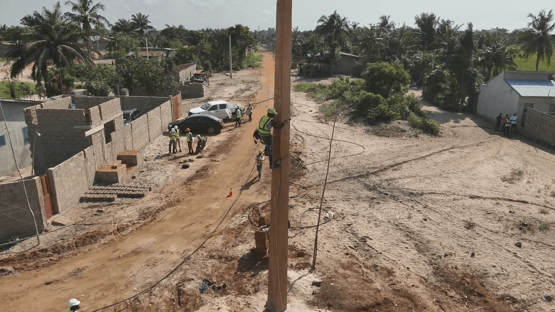 EnergyRoute des Pêches, Bénin2025-2026
Electrification of the Route des Pêches for Sobelec
Multi-phase mission for Sobelec (Bouygues Energies Services subsidiary) on the electrification project: deployment of a Clovis collaboration platform and regular drone capture for video site reporting.
- Key figure
- Clovis
- plateforme collaborative déployée
TechPlateforme ClovisReporting vidéo chantierCaptation droneSuivi avancementClient : Sobelec (filiale Bouygues Energies Services)
See case study