


Agriculture · 2025
200 ha LiDAR survey of the Okpara Farm
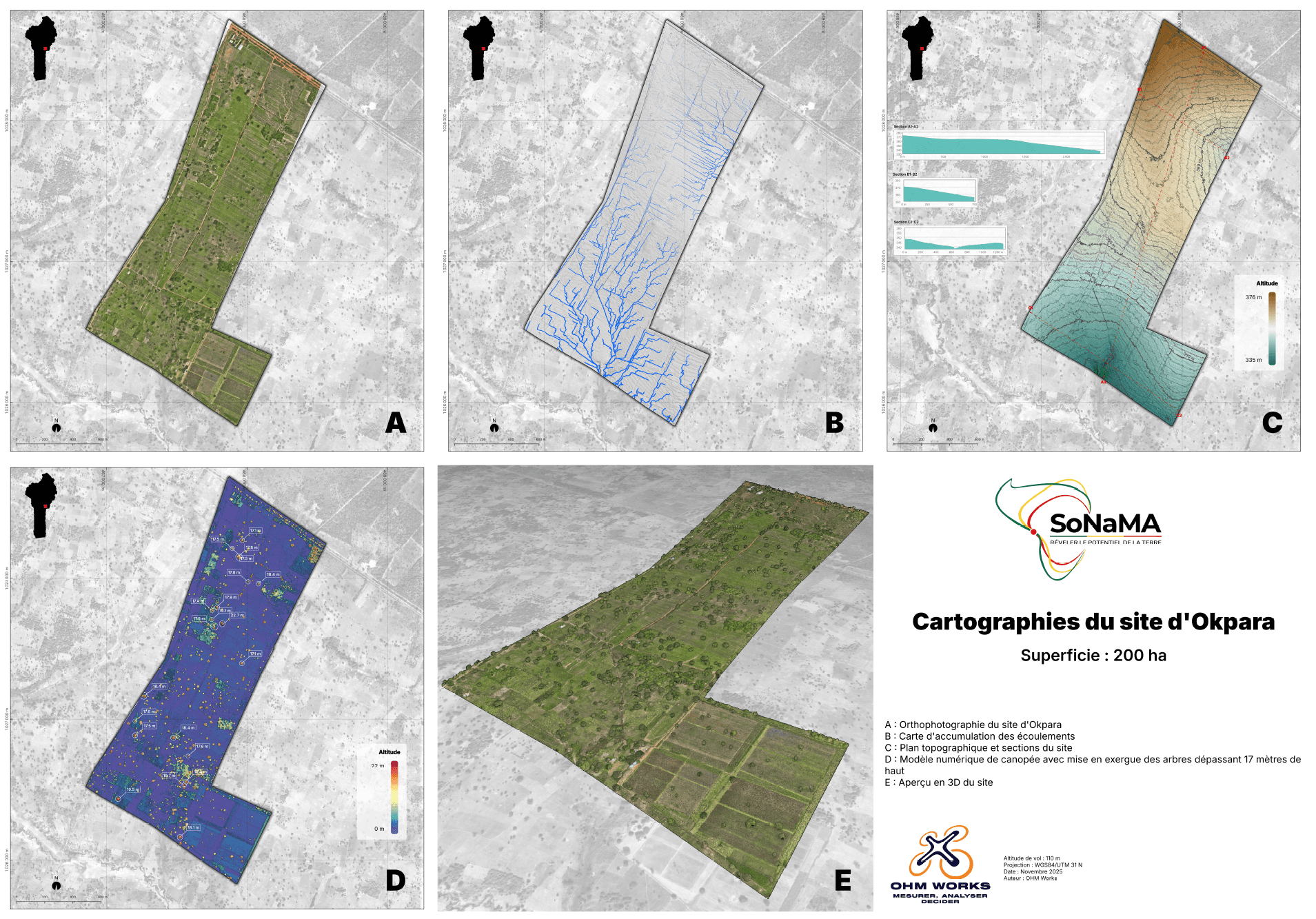
LiDAR mapping of a large-scale integrated agricultural zone for SoNaMA. Orthophoto, DTM/DSM, point cloud and tree detection. Multi-layer restitution for agricultural planning and canopy monitoring.
- Client
- SoNaMA
- Location
- Parakou, Bénin
- Year
- 2025
- Key metric
- 200 ha · zone agricole modélisée
The context
Société Nationale de Mécanisation Agricole (SoNaMA) operates the Okpara integrated agricultural site, a 200-hectare zone near Parakou. To plan irrigation, monitor plot evolution and identify trees exceeding plant-health thresholds, they needed centimetric multi-layer mapping: bare ground under vegetation, canopy, water bodies and tree inventory. Classical aerial photogrammetry alone would not have reconstructed the ground under the canopy. Airborne LiDAR offered the complete solution in a single mission.
Our method
A single day of high-density airborne LiDAR capture, paired with a photogrammetric RGB flight for colour. Layout of RTK-georeferenced GCPs across the entire site to guarantee centimetric absolute accuracy. Multi-layer processing: DTM extraction via automatic ground classification, CHM generation by DSM-DTM subtraction, automatic detection of each tree via canopy segmentation. Manual QC complemented the automatic classification on areas where the LiDAR signature was ambiguous.
What we delivered
- Georeferenced centimetric orthophoto (GeoTIFF, GSD 2 cm/pixel)
- DTM and DSM in GeoTIFF format, UTM 31N projection
- CHM (Canopy Height Model)
- Classified LAS/LAZ point cloud (ground, vegetation, built, water)
- GIS layer of detected trees with individual height (SHP, GeoJSON)
- Thematic mapping of trees exceeding 17 metres
- Topographic plan usable for irrigation planning
- Technical report with QC and achieved accuracy
The outcome
SoNaMA now has a georeferenced cartographic layer directly usable in their internal GIS. Automatic detection surfaced specimens above thresholds that had been previously uninventoried. The data also serves as a temporal reference: a second pass in 12 or 24 months will precisely measure canopy growth and plot evolution. The mission demonstrated that an airborne LiDAR survey on 200 hectares of integrated agricultural zone is delivered in under three weeks, vs several months for an equivalent manual inventory.
Technologies used : LiDAR aéroporté · Orthophotographie · MNT / MNS · Détection d'arbres
Client : SoNaMA (Société Nationale de Mécanisation Agricole)
A similar project in mind?
Let's discuss — firm quote within 48 h.
XY accuracy < 3 cm, volumetric tolerance ± 1 %. Benin, West Africa and France.