


Drone Parakou · Bénin
Drone Parakou — agricultural mapping, LiDAR and photogrammetry
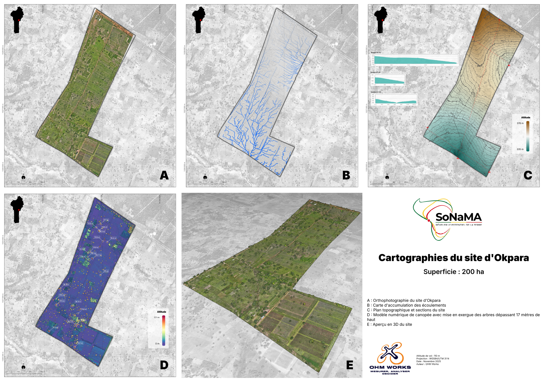
OHM WORKS delivered the full LiDAR survey of the Okpara farm for SoNaMA — 200 hectares of farmland modelled. Our agriculture and forestry expertise covers all of Borgou and Donga departments to map farms, optimise inputs and track yields.
- Coverage
- 150 km
- Quote turnaround
- 48 h
- XY accuracy
- < 3 cm
- Case studies
- 1
Why local
Drone-based agricultural expertise in Northern Benin.
ANAC authorisations adapted to rural ops
For rural agricultural missions, we handle ANAC declarations in a simplified framework — fewer urban constraints, but identical rigour on flight safety and compliance.
Familiarity with agricultural value chains
Cotton, soybean, cashew, oil palm: our acquisition protocols and analytical indices (NDVI, NDRE, MSAVI) are calibrated for Northern Benin and neighbouring Côte d'Ivoire crops.
On-site base camp
For multi-day missions (200+ hectares), we set up base camp in Parakou or directly on the farm. Mobilisation from Cotonou is one day's road journey.
Documented SoNaMA reference
200 hectares of the Okpara farm mapped in LiDAR — DTM, DSM, automated tree counting, orthophotography. This reference now drives SoNaMA's agronomic planning.
Available services
Our drone missions in Parakou
In Parakou and across Borgou, demand centres on precision agriculture, forestry (inventories, biomass monitoring) and urban planning of the regional capital. Our four most-mobilised disciplines:
Precision Agriculture
Vigor maps, plant counting, disease detection and multispectral monitoring.
DiscoverForest Management
Aerial stand inventory, biomass, under-canopy mapping and carbon monitoring.
DiscoverUrban Planning & Construction
Topographic surveys, site monitoring, volumetrics and BIM.
DiscoverMining & Quarries
±1% volumetrics, magnetometric exploration, autonomous surveillance, HSE compliance.
Discover
On the ground
Our case studies in Parakou
Our flagship reference: the LiDAR survey of the Okpara farm for SoNaMA — 200 hectares mapped, automated tree counting, DTM for irrigation planning, deliverables compatible with agronomic GIS workflows.
Coverage of Northern Benin
Mobilisation from Cotonou (8 hours by road) with temporary base camp in Parakou for multi-day missions. Our radius covers Borgou (Parakou, Tchaourou, N'Dali), Donga (Djougou, Bassila) and Atacora for ad hoc missions.
- Service radius
- 150 km
- On-site mobilisation
- ≤ 72 h
Drone regulation in Northern Benin
Northern Benin has fewer urban airspace constraints but requires particular attention to military zones and national parks (Pendjari, W). We coordinate upstream with ANAC and, where needed, with local administrations.
- ANAC Benin — Simplified declaration in rural areas, specific authorisations for military zones.
- Agricultural zone — SORA analysis adapted — low ground-population density, but coordination with farm operators.
- National parks — CENAGREF coordination if a mission falls within or near a protected area.
Frequently asked questions — local
Drone in Parakou — your questions
What's the value of drones for agriculture in Northern Benin?
Three documented benefits: vigour mapping (NDVI) that cuts chemical inputs by 30 %, automated plant counting that saves 25 % of field time, and DTM for optimising irrigation and drainage networks.
How long to map a 100-hectare farm?
On multispectral photogrammetry, expect one flight day for 100 ha at 5 cm/pixel. On high-density LiDAR, two days. Deliverables (orthophoto, NDVI, DTM) are produced within 7 to 10 business days.
What accuracy on palm or tree counting?
> 98 % accuracy on adult palm groves with high-resolution photogrammetry. On young plantations or dense crops, accuracy depends on the spacing between plants — we calibrate the algorithm per mission.
Are your deliverables compatible with QGIS / ArcGIS?
Yes. All our deliverables ship in standard georeferenced formats: GeoTIFF, SHP, LAS/LAZ, OBJ. Default projection: WGS84 / UTM 31N. On request, we also deliver in local Benin reference or any custom EPSG.
Can you monitor a farm over time?
Yes. We offer monitoring programmes (monthly, quarterly, seasonal) with calibrated acquisition to enable multi-temporal comparison of vigour, biomass and cover indices. Ideal for yield tracking or early detection of water stress.
A project in Parakou?
Firm quote within 48 h, team based in Cotonou.
Photogrammetry, LiDAR, thermography, 3D modelling — XY accuracy < 3 cm on every deliverable.