


Drone Cotonou · Bénin
Drone services in Cotonou — photogrammetry, LiDAR & GIS
OHM WORKS operates its main office in Cotonou. Our teams cover all of Littoral and Atlantique departments for aerial photogrammetry, LiDAR surveys, thermographic inspection and 3D modelling — XY < 3 cm accuracy and a firm quote within 48 hours.
- Coverage
- 80 km
- Quote turnaround
- 48 h
- XY accuracy
- < 3 cm
- Case studies
- 5
Why local
A team based in Cotonou — not a vendor passing through.
ANAC authorisations on file
Every flight we operate is declared to Benin's Civil Aviation Authority. We handle SORA risk assessment, NOTAM filings and specific authorisations for sensitive zones (CNHB, Autonomous Port, Cardinal Bernardin Gantin International Airport).
Pilots and engineers on the ground
The technical team lives and works in Cotonou. No middlemen, no outsourcing: you talk directly to the people who fly the drone, process your data and deliver your results.
On site within 72 h
For any site in Greater Cotonou, we can be on the ground within 72 hours of quote approval. For urgent missions (blocked construction site, incident, ad hoc inspection), we prioritise scheduling.
Deep knowledge of local sites
Place de l'Amazone, Route des Pêches, GMK Stadium, Cadjèhoun business district: we've already mapped Cotonou's main sites. That knowledge translates into fewer surprises and tighter budget framing.
Available services
Our drone missions in Cotonou
In Cotonou, demand centres on construction monitoring, telecom and energy infrastructure inspection, and 3D modelling of public sites. Our four most-mobilised disciplines locally:
Urban Planning & Construction
Topographic surveys, site monitoring, volumetrics and BIM.
DiscoverTelecom
Tower audits, infrastructure inventories, digital twins.
DiscoverEnergy
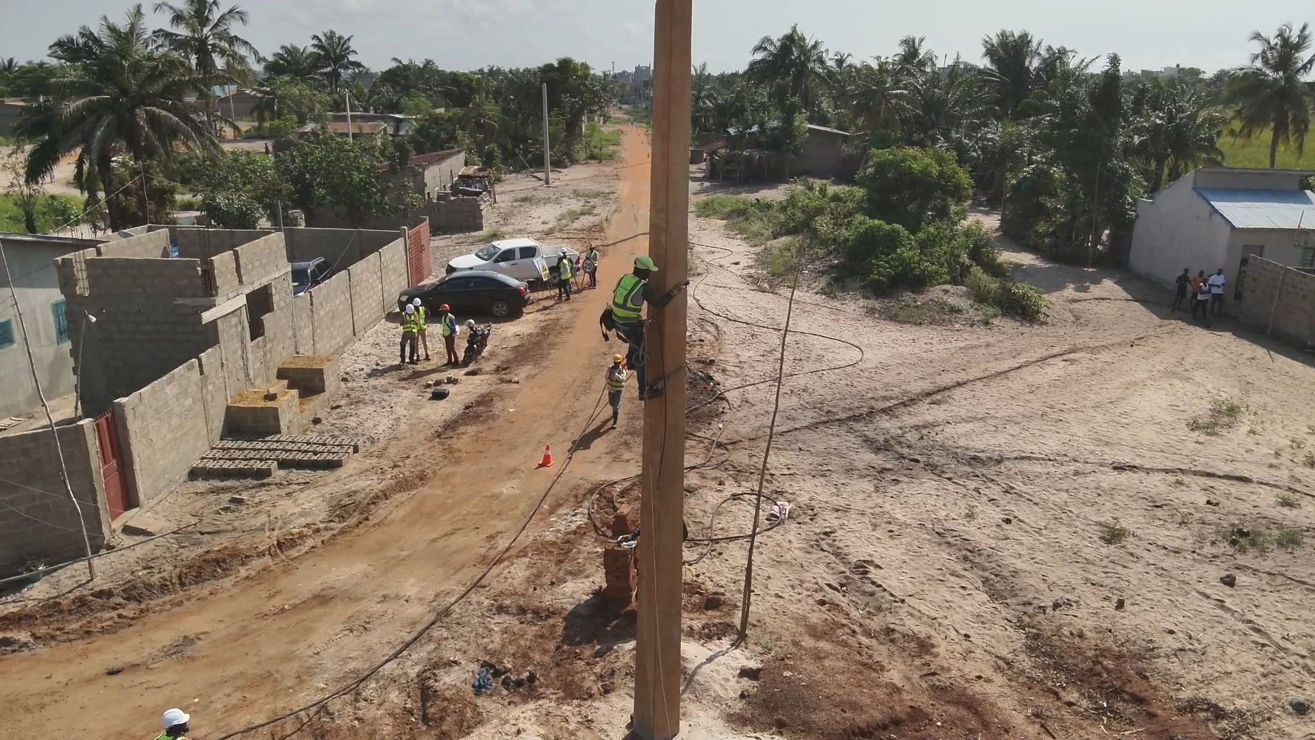
LiDAR network inspection, thermography, sag measurements.
DiscoverIndustrial inspection
Thermography, structural and building inspection without lifts — HSE-compliant reports.
Discover
On the ground
Our case studies in Cotonou
Four landmark missions delivered in Cotonou for Gregori International, MOOV Africa Bénin, SBEE and Sobelec — from FIFA-grade construction monitoring to telecom-tower digital twins and HTB power-line LiDAR-thermal inspection.
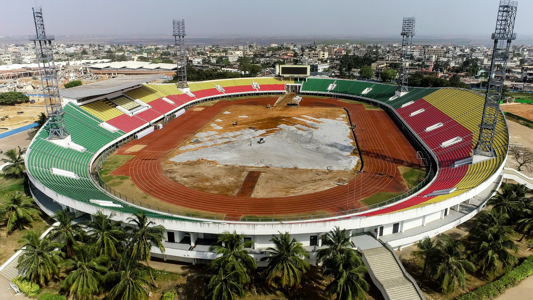
Gregori International · 2024-2025
FIFA — mise aux normes du stade national
Photogrammétrie · Reporting hebdomadaire · Modélisation 3D
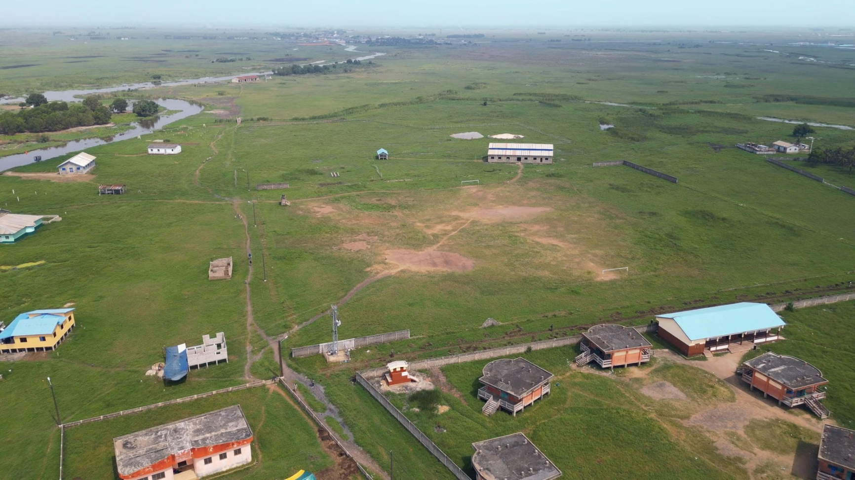
Inspired Design · 2024-2025
Lacustre — fondations sur pilotis suivies par drone
Photogrammétrie · Modélisation 3D · Reporting photo/vidéo
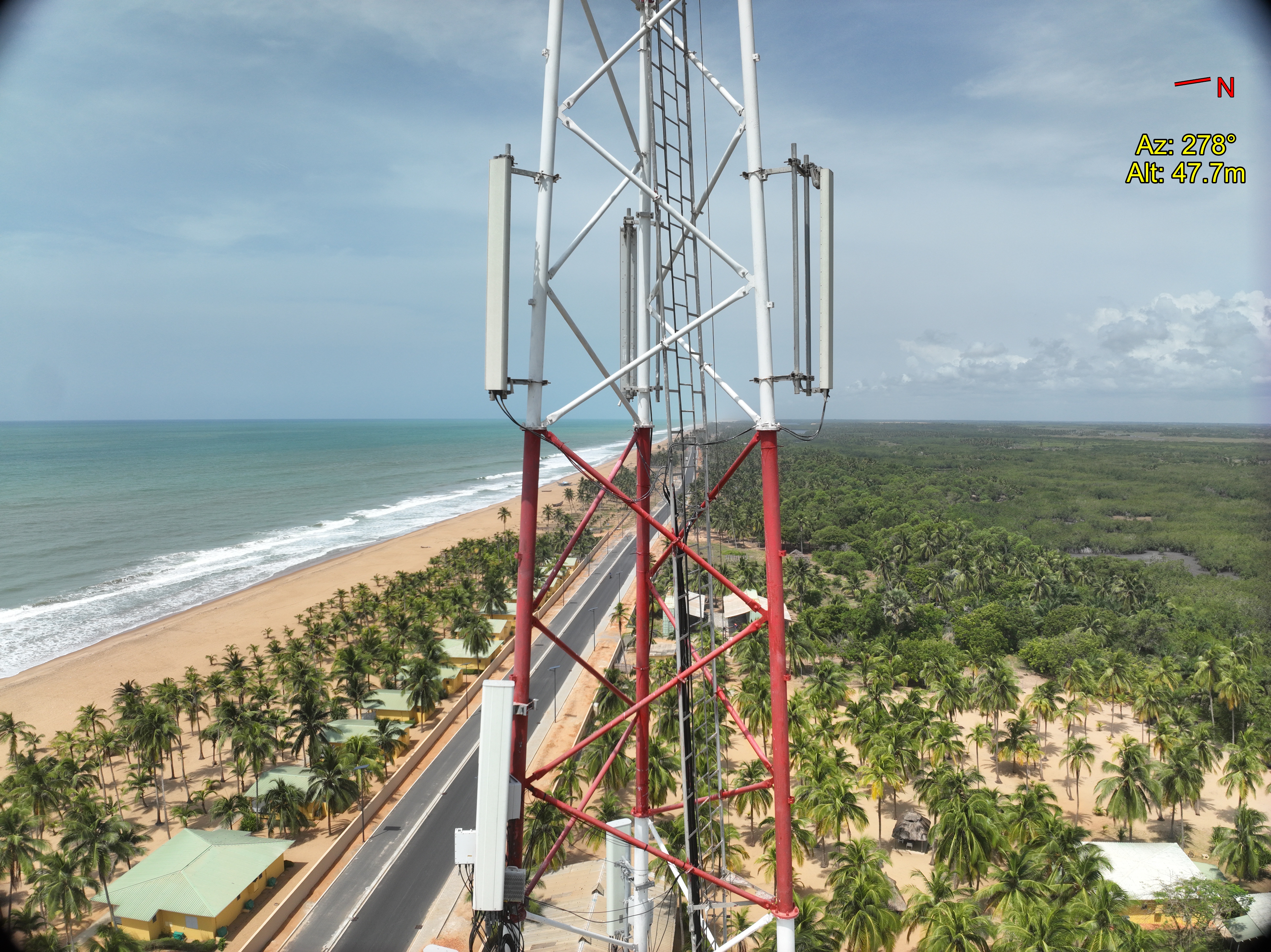
MOOV Africa Bénin · 2026
4 — pylônes BTS jumellés numériquement
Inventaire composants · Jumeau numérique 3D · Tour virtuel 360°
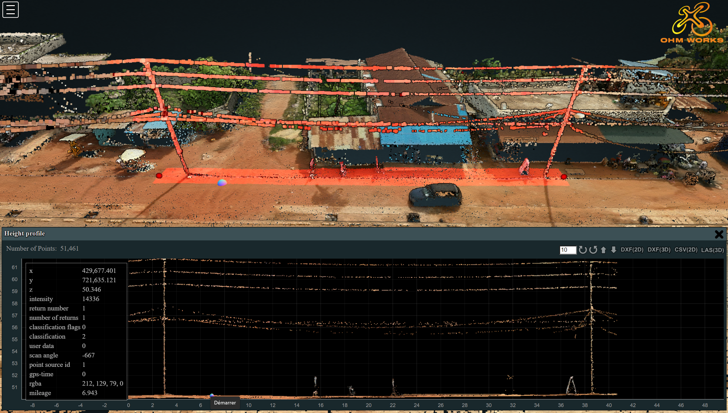
SBEE · 2026
HTB — lignes aériennes inspectées LiDAR + thermo
LiDAR aéroporté · Mesure de flèche · Détection points chauds
Sobelec · 2025-2026
Clovis — plateforme collaborative déployée
Plateforme Clovis · Reporting vidéo chantier · Captation drone
Service area from Cotonou
From our Cotonou base, we cover Littoral, Atlantique and Ouémé departments with immediate mobilisation (≤ 72 h). For missions further north (Zou, Borgou, Collines), we deploy the team with temporary on-site accommodation — the operational fee stays transparent and is fixed at quote stage.
- Service radius
- 80 km
- On-site mobilisation
- ≤ 72 h
Drone regulation in Cotonou
Cotonou hosts several constrained airspaces: Cardinal Bernardin Gantin International Airport, military heliport, port zone. For every mission, we run the SORA risk assessment, file NOTAMs where required and liaise with ANAC ahead of time.
- ANAC Benin — Prior flight declaration, specific authorisations for dense urban areas and sensitive sites.
- SORA analysis — Systematic assessment of ground, air and population risks before every urban mission.
- NOTAM if required — Notice to Airmen filed for flights near airport or military zones.
Frequently asked questions — local
Drone in Cotonou — your questions
What's your turnaround for a mission in Cotonou?
For a site in Greater Cotonou (Littoral, Atlantique), we mobilise the team within 72 hours of quote approval. Spot inspections and weekly construction monitoring are scheduled ahead with a recurring slot.
Can you fly a drone in dense urban areas of Cotonou?
Yes, with constraints. We run a specific SORA analysis, file an ANAC declaration and, depending on the zone, a NOTAM. Neighbourhoods close to the airport or military zones require additional authorisations — we handle those upstream.
What accuracy do you reach on a Cotonou mission?
On photogrammetry: XY < 3 cm and Z < 5 cm with RTK GCPs. On airborne LiDAR: 200 points/m² standard, up to 800 pts/m² in high-density mode. For stockpile or earthworks volumetrics, the tolerance is ± 1 %.
Do you work with Beninese public administrations?
Yes. We've delivered missions for ANPT (UNESCO Royal Palaces of Abomey), SoNaMA (Okpara farm) and SBEE (HTB power lines). We know how to handle administrative documentation, ANAC traceability and deliverables compliant with public-sector standards.
What are your delivery times after the flight in Cotonou?
Orthophoto and DTM/DSM within 5 to 10 business days depending on volume. 3D modelling and digital twin within 15 days. Construction monitoring reports: J+2 after the flight for standard weekly reports.
A project in Cotonou?
Firm quote within 48 h, team based in Cotonou.
Photogrammetry, LiDAR, thermography, 3D modelling — XY accuracy < 3 cm on every deliverable.