Skip to content
OHM WORKSMEASURE · ANALYZE · DECIDE
Vue aérienne d'une exploitation minière à ciel ouvert — levé drone OHM WORKS
← All industries

Industry

Mining & Quarries

Drone solutions for quarry and mine operations — fast, precise and cost-effective topographic surveys. Aerial imagery, photogrammetry and LiDAR combined with AI for immediately actionable data: informed decisions, supported field teams, guaranteed safety.

Volumetric tolerance
± 1 %
Standard delivery time
1-2 j
HSE-compliant via drone
100 %

Applications

  • Stockpile measurements

    Measure all your stockpiles, cuts and fills in a few hours within ±1% tolerance. Full-site coverage in record time, safely and without halting operations.

  • Blasting planning

    Optimization of extraction plans, precise exclusion zone definition, detection of potential instabilities before blast events. High-precision topographic data to prepare every campaign safely.

  • Geometric control

    Precise measurement of ramps, working faces, slope angles, berms and bench heights. Automated theoretical-vs-actual plan comparison — compliance reports delivered in 24 to 48 hours.

  • Environmental monitoring

    Settlement pond surveillance, ecological rehabilitation tracking, erosion and dust dispersion mapping. Data compliant with regulatory requirements for environmental reports and site audits.

  • Surveillance & security

    Autonomous solution for round-the-clock site surveillance. Thermal cameras for intruder detection with automatic notifications. Face audits without personnel exposure to risk zones.

  • Mining exploration

    Magnetometric measurements generating mineral presence maps and supporting blasting planning. Identify high-potential extraction zones before committing to costly operations.

Measurement & extraction monitoring

From stockpile to extraction plan — figures that hold

Maillage 3D triangulé sur un stockpile minier — mesure de cubature par drone

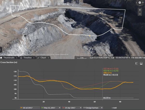
Stockpile measurement & volumetrics

Every stock measured at ±1 %, in a matter of hours

3D triangulated mesh on each pile, automatic volume computation between the measured surface and the reference ground. A single drone flight replaces several days of ground survey — no production stoppage, no operator on the pile, with a volumetric tolerance that meets end-of-month inventory requirements.

  • ±1 % volumetric tolerance on stocks, cut and fill
  • Volumetrics delivered in 24 to 48 h, exportable as PDF, CSV or DXF
  • Acquisition without halting machinery or evacuating the area
Comparaison de coupes transversales sur plusieurs campagnes — suivi d'évolution d'une carrière

Evolution monitoring & planning

Compare every campaign, anticipate extraction

Repeat surveys at regular intervals, aligned on the same georeferenced grid. DTM differential between two campaigns, overlaid cross sections, tracking of the blast face and exploited land. Deviations from the extraction plan are spotted visually and quantified, month after month.

  • Cross-campaign comparison on the same grid — cm-level deltas
  • Long profiles, cross sections and differential DTM, all automated
  • 100 % drone HSE compliance — no personnel exposed to active faces

Our method

A proven three-step protocol, from technical brief to delivery of usable data.

  1. 01Step 1

    Brief & SORA analysis

    Technical scope: site perimeter, mission type (volumetrics, geometric control, magnetometry), expected deliverables. SORA risk analysis for operations near active machinery, ANAC / DGAC authorisation.

  2. 02Step 2

    Certified drone acquisition

    Photogrammetric or LiDAR flight, RTK GNSS and georeferenced GCP targets for centimetric accuracy. Full site surveyed in a few hours — minimum 80/70 overlap, RGB or thermal sensors as needed.

  3. 03Step 3

    Volumetrics & deliverables

    Photogrammetry via Agisoft Metashape or Pix4D, ±1% volumetric computation, geometric profiles, high-resolution DTM and HSE compliance reports. Full delivery within 1 to 2 working days.