


Budget · Drone Benin
Cost of a drone mission in Benin in 2026: the factors that set your budget
How much does a drone mission cost in Benin? No universal price per m²: 6 factors set the budget (surface, sensor, accuracy, deliverables, regulation, logistics). The one public fixed cost: the ANAC fee (600,000 XOF / 6 months). How to budget accurately.
- Publication date
- 12 June 2026
- Reading time
- 9 min
"How much does a drone mission cost in Benin?" It's the first question a client asks — and the most legitimate. The honest answer isn't a price per square metre, but a reading grid. A photogrammetric survey of a rural plot and an under-canopy LiDAR survey of several hundred hectares share neither the same method, the same sensors, nor the same budget. Here's what really determines the cost of a mission, how to budget accurately, and the one public fixed cost to know: the ANAC fee.
Note: this article lays out the cost factors of a professional drone mission in Benin in general terms. We don't publish OHM WORKS rates — every mission is quoted individually, because every site is different. For a firm, detailed quote, describe your project: we come back within 48 hours.
Why there's no universal "price per m²"
Some providers advertise a per-hectare rate. Reassuring on paper, misleading in practice. Two missions of identical surface can cost four times more or less depending on the sensor deployed, the accuracy required, site accessibility and regulatory constraints. A flat rate hides those gaps: either it over-charges simple missions, or it under-prices complex ones — and in that second case, deliverable quality suffers.
A serious quote always starts from the real need: which deliverable, at what accuracy, for which decision. That logic protects your budget — and the reliability of your data.
The six factors that determine a mission's cost
Whatever the provider, a drone mission's budget is built around six variables. Understanding them means knowing how to read a quote and compare two offers on equal footing.
1. Site surface and accessibility
Surface drives flight time and data-processing volume. But accessibility weighs just as much: a site in central Cotonou, 30 minutes from our base, doesn't mobilise the same logistics as a forest zone in Atacora 10 hours away by road, which requires an on-site base camp. The "travel & logistics" line can be a significant share of a mission in the north of the country.
2. Sensor type
This is the most structuring factor. An RGB camera for classic photogrammetry, a multispectral sensor for precision agriculture, a thermal camera for inspection, or airborne LiDAR to survey under forest cover: these sensors differ in amortisation cost and processing complexity. LiDAR in particular mobilises equipment and a software chain that place it in a category of its own.
3. Accuracy required
Reaching XY accuracy below 3 cm and Z below 5 cm requires ground control points (GCPs) surveyed by RTK GPS, a tight flight plan and rigorous quality control. If your project tolerates decimetre accuracy, the protocol lightens. The question isn't "as accurate as possible" but "the accuracy actually needed for your decision" — over-spec'ing accuracy inflates the budget for no benefit.
4. Expected deliverables
A georeferenced orthophoto, a digital terrain model (DTM), a classified point cloud, a meshed 3D model, a volume report or a full digital twin don't require the same post-processing time. The richer the deliverable chain, the larger the "office" share of the quote — often greater than the "flight" share.
5. Regulatory constraints
A mission in a sensitive zone — airport proximity, UNESCO site, military installation, public event — requires specific authorisations, sometimes a SORA analysis and NOTAM filing. These steps mobilise administrative time ahead of the flight. A provider who handles the full ANAC file spares you that work, but the service has a real mobilisation cost. For the full framework, see our ANAC regulation guide.
6. Location and season
Benin's rainy season (roughly April–July and September–October) reduces usable flight windows and can extend lead times. A mission plannable in the dry season is easier to optimise than an urgent intervention in the middle of the wet season. Location also affects the local authorisations to obtain from municipalities or site managers.
The one public fixed cost: the ANAC fee
Whatever the provider, operating a drone commercially in Benin requires an operating authorisation issued by the National Civil Aviation Agency. This fee is roughly 600,000 XOF (~€915) for a validity period of 6 months. It's the entry ticket to operate legally on the territory, regardless of the number of missions carried out over the period.
On top of this base fee can come, depending on the mission, the per-site flight file and, where applicable, NOTAM publication and SORA analysis. A certified operator folds these steps into its offer — precisely what distinguishes a compliant provider from an amateur whose deliverables will hold no legal value in a dispute.
The real comparison: drone vs conventional methods
The right question isn't "is the drone expensive?" but "compared to what?". On most use cases, high-precision aerial capture shifts the cost/value cursor in your favour:
- Topography & construction — a drone survey covers in one day what a survey crew takes several to measure, with point density on another scale. Field-time savings around 25 %.
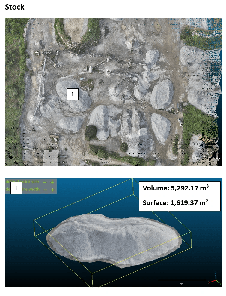
- Mining & quarries — a drone stockpile volume (volumetric tolerance ± 1 %) replaces approximate manual measurements, securing both invoicing and HSE compliance.
- Agriculture — multispectral mapping targets fertilisation and spraying precisely: input reduction around 30 %, yield improvement around 15 % on monitored value chains.
- Inspection — a drone tower or line inspection removes work at height, its risks and its service downtime. Safety has a value, and it enters the calculation.
In other words: the cost of a drone mission always compares to the full cost of the method it replaces — time, risk, downtime, imprecision. That's where the return on investment plays out.
How to budget accurately: the four-step method
- Start from the decision, not the sensor. What do you need to decide thanks to this data? That answer sets the accuracy and deliverables actually needed.
- Describe the site precisely — surface, location, accessibility, vegetation cover, access constraints. The sharper the brief, the more accurate and stable the quote.
- Ask for a detailed quote, line by line: flight, processing, deliverables, regulatory steps, travel. Avoid opaque packages.
- Compare on equal footing — two quotes are only comparable if they target the same accuracy and the same deliverables. A lower price for lower accuracy isn't a saving, it's a different product.
What a serious quote must contain
Before signing, check that your quote details: the collection method (sensor, GSD, overlap, flight plan), the processing steps and quality controls, the exhaustive list of deliverables with their formats (GeoTIFF, LAS/LAZ, SHP, OBJ, PDF…) and projection system, the handling of ANAC procedures, and the delivery lead times. A quote that fits on a single "drone mapping: amount" line protects you from nothing.
At OHM WORKS, every quote follows this structure: WGS84 / UTM Zone 31N projection by default, XY accuracy < 3 cm, volumetric tolerance ± 1 %, ANAC file included, and a firm delivery deadline. No catalogue rate — a quote tailored to your site and your decision.
Going further
This article complements our complete drone guide for Benin (accuracy, sectors, lead times) and our ANAC regulation guide. To understand our capture methods, see the airborne LiDAR explainer and our documented case studies.
Ready to switch to drones?
Let's discuss your project in 30 minutes.
Firm quote within 48 hours. Coverage across Benin, West Africa and France. XY accuracy < 3 cm, volumetric tolerance ± 1 %.